

Untersuchungsgebiete vom Projekt "Integrales Schalenwildmanagement im Bergwald"
Die Untersuchungen werden exemplarisch in zwei Projektgebieten durchgeführt, die sich bezüglich der Lebensraumsituation (insb. Wald-Offenland-Verteilung) und damit auch des jagdlichen Managements unterscheiden.
Dadurch werden unterschiedliche, aber für den Bayerischen Alpenraum insgesamt typische Ausgangssituationen abgebildet.
English version
Background and aims
Montane forest ecosystems are valuable habitat to several characteristic game species of the Bavarian Alps including roe deer (Capreolus capreolus), red deer (Cervus elaphus) and chamois (Rupicapra rupicapra). From a human perspective, montane forests also provide important functions such as the protection of Alpine valleys from mudflows, rockfalls and avalanches. Consequently, forest stands with protective purposes are highly sensitive to browsing damage by ungulates. Additionally, alpine regions are influenced by traditional forms of agriculture (e.g., grazing; so called “Almwirtschaft”) and growing numbers of tourists and recreational activities.
As a result of these competing land-use activities and demands on this ecosystem an integrative wildlife management concept is required. For such an integrative approach a foundation of objective data on all relevant species and land-user groups is needed. Accordingly, the Bavarian state institute for forestry (LWF) in cooperation with the Bavarian state forest service (BaySF) initiated a research project aiming to obtain detailed and objective data on
a) the current population status (size/density and condition/constitution),
b) the space use and habitat preferences throughout the year
for the three ungulate species: roe deer, red deer and chamois.
Methods and study areas
Two study areas which are representative for the alpine region of Bavaria were chosen for this research project. Both areas are managed by the Bavarian state forest service:
1) Karwendel mountain range, within the management district ‘Bad Tölz’
2) Geigelstein-Kampenwand, within the management district ‘Ruhpolding’
These study areas differ with regard to the amount of open- and woodland-areas, elevation gradient as well as the distribution and amount of human impact.
Population size and density will be estimated with the spatial-explicit capture-recapture method (SECR). For this, fresh droppings of the three ungulate species are collected in two field seasons and genetically analyzed for individual identification. Additionally, obtained data on presence of the three species during these field surveys is used for habitat suitability models. Intensive camera trap surveys help to gain insight on the changes in habitat preferences and space use throughout the year. Lastly, data from hunting bags and additional information on the exact age and body condition of harvested animals are collected for analyses regarding the current population state of the three ungulate species.
Bei der Auswahl und Abgrenzung der Gebiete wurden insbesondere folgende Kriterien berücksichtigt
- Jagdliches Management in einer Hand;
- Vorkommen aller drei Schalenwildarten;
- Ausreichende Flächengröße (große Aktionsradien von Gams- bzw. Rotwild);
- Vorhandensein von Sommer- und Wintereinständen;
- Bereiche unterschiedlicher Bejagungsintensität;
- Vorkommen von Schutzwaldsanierungs-, FFH- und almwirtschaftlichen Flächen;
- Umfangreiche und v. a. aktuelle Datengrundlagen (insb. Forsteinrichtung, Waldinventur)
Untersuchungsgebiete
 Zoombild vorhanden
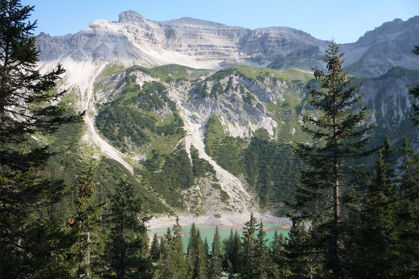
Gamswildlebensräume im Karwendel (Foto: T. Kudernatsch)
Das Projektgebiet „Geigelstein-Kampenwand“ liegt in den Chiemgauer Alpen und hat eine Höhenamplitude von ca. 600 bis 1.800 m NN. Die überwiegenden Bereiche sind bewaldet, Fels- und Mattenbereiche spielen eine untergeordnete Rolle. Das Projektgebiet „Karwendel“ zeichnet sich insg. durch eine größere Höhenamplitude (800 bis 2.250 m NN) aus, weshalb dort in größerem Umfang auch Fels- und Schuttbereiche sowie alpine Rasen zu finden sind.
Beschreibung zum Ausdrucken
Zurück zur Projektseite